
Navigating the Annapurna Circuit is a journey of a lifetime. While the trail is well-trodden, a detailed map remains your most crucial tool. It’s not just about staying on the path; it’s about understanding the terrain, planning for altitude, and discovering the hidden gems along the way.
This comprehensive guide breaks down the Annapurna Circuit trek map, helping you to read its symbols, understand the key sections, and plan your perfect adventure.
How to Read an Annapurna Circuit Trek Map
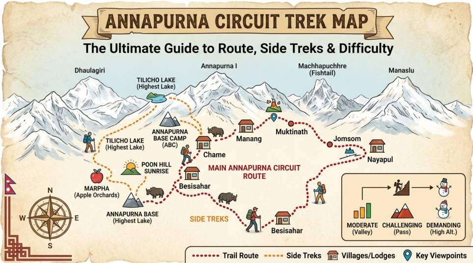
A good map of the Annapurna Circuit is a detailed topographical resource. Here’s what the key symbols and colors mean:
- Main Route (Solid Line): This is the classic, anti-clockwise path that most trekkers follow. It is the most well-established trail, taking you from the lowlands of Besisahar up to the high-altitude Thorong La Pass.
- Side Treks (Dotted or Dashed Lines): These are alternative or optional routes. The map will clearly show offshoots to popular detours like Tilicho Lake or the Upper Pisang trail, allowing you to choose your own adventure.
- Elevation Markers: Look for numbers next to key villages or passes. These indicate the altitude in meters, which is essential for monitoring your ascent and preventing altitude sickness.
- Symbols & Icons: Maps use universally recognized symbols. Look for small icons marking teahouses, health posts (a red cross), viewpoints (binoculars), monasteries (a stupa), and bridges.
Key Sections of the Annapurna Circuit Route
The Annapurna Circuit is roughly 160-230 km long, depending on where you start and which detours you take. The map breaks the journey into distinct sections, each with its own character.
1. The Lush Lowlands: From Besisahar to Chame
This is the green, confident start of the trek. On your map, you’ll see a winding trail through subtropical forests, terraced rice paddies, and traditional villages. The terrain here is relatively easy, with a gradual but steady elevation gain.
- Altitude Range: 760m (Besisahar) to 2,710m (Chame)
- Terrain: Well-marked trail, often following the Marsyangdi River.
2. The Alpine Transition: Chame to Manang
This is where the landscape transforms. The map will show the trail getting higher and the terrain becoming more rugged. You’ll pass through dense pine forests and enter a wide, arid valley. This section offers the first spectacular, close-up views of Annapurna II and Gangapurna.
- Altitude Range: 2,710m (Chame) to 3,540m (Manang)
- Terrain: Rocky paths, with some steep sections and exposed areas.
3. The High-Altitude Challenge: Manang to Thorong La Pass
This is the most critical and challenging part of the trek. On the map, the trail will climb steeply away from the main valley. The distance is short, but the elevation gain is significant, making it mentally and physically demanding.
- Altitude Range: 3,540m (Manang) to 5,416m (Thorong La Pass)
- Key Stops: Yak Kharka (4,050m) and Thorong Phedi (4,450m) or High Camp (4,800m). Your map will show these as crucial overnight stops before the pass.
4. The Descent & Mustang Valley: Thorong La Pass to Jomsom
After crossing the pass, the map shows a long, steep descent into the rugged, arid landscape of the Mustang region. You’ll pass through the sacred pilgrimage site of Muktinath before continuing into the Kali Gandaki Gorge.
- Altitude Range: 5,416m (Pass) to 2,720m (Jomsom)
- Terrain: A mix of rocky, steep descents and then wide, dusty trails in the lower valley.
Key Side Treks & Detours to Look for on Your Map
A good map highlights the incredible side trips that make the Annapurna Circuit more than just a single trail.
- Tilicho Lake: Marked as a demanding but rewarding 2-3 day detour from Manang. The trail branches off to the west and leads to the spectacular high-altitude Tilicho Lake at 4,919m.
- Ice Lake (Kicho Tal): A day hike from Manang. The map shows this trail climbing steeply behind the village to a stunning viewpoint and serene alpine lake.
- Ghorepani & Poon Hill: On the far western side of the map, you’ll see this popular add-on. The trail branches off from Tatopani and leads to the famous sunrise viewpoint of Poon Hill (3,210m).
- Nar Phu Valley: For the truly adventurous, your map may show this remote, restricted-area trek that branches off the main circuit near Koto.
Understanding the Annapurna Circuit Trek Difficulty
The Annapurna Circuit is considered a moderately difficult trek, but a map helps you understand where the challenges lie.
| Section | Key Challenge | Difficulty | Map Insight |
| Lowlands | Long walking days | Easy to Moderate | Shows a gradual, consistent elevation increase. |
| Manang Valley | Increasing altitude, thinner air | Moderate | The elevation lines on the map get closer together, indicating a steeper climb. |
| High Pass | Extreme altitude, cold, steep ascent/descent on a single day | Difficult | The map will show the most condensed elevation lines on the entire route. |
| Mustang Valley | Long, dusty trail, strong winds | Easy to Moderate | The wide-open spaces and flat terrain on the map indicate a less strenuous path. |
Your Annapurna Circuit trek map is more than a navigation tool; it is the blueprint for your entire journey. Use it to understand the elevation changes, plan your acclimatization stops, and discover the hidden trails that make this one of the most diverse and rewarding treks in the world.

 English
  Deutsch
  Français
  Português
  Español
0 Comment